Ashgabat and Nisa
Last updated
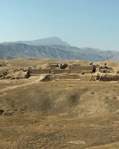
Photo: Hans Birger Nilsen, CC BY-SA 2.0, via Wikimedia Commons, modified (cropped)

At a glance
- Velayat
- Location: Bagyr settlement, Etrap of Rukhabad, Akhal Vilayet
- OpenStreetMap's reverse lookup at UNESCO's Old Nisa point returns “Ashgabat, Turkmenistan”, region code TM-S.
- What it is
- The Parthian Fortresses of Nisa consist of two tells of Old and New Nisa, indicating the site of one of the earliest and most important cities of the Parthian Empire, a major power from the mid 3rd century BC to the 3rd century AD.
- UNESCO World Heritage
- The Parthian Fortresses of Nisa were inscribed on UNESCO's World Heritage List in 2007 as a cultural property in two parts, Old Nisa and New Nisa.
The capital, and the ruins of a far older city just outside it.
History and what you see
Situated at the crossroads of important commercial and strategic axes, this powerful empire formed a barrier to Roman expansion while serving as an important communication and trading centre between east and west, north and south.
They conserve the unexcavated remains of an ancient civilization which skilfully combined its own traditional cultural elements with those of the Hellenistic and Roman west.
Archaeological excavations in two parts of the site have revealed richly decorated architecture, illustrative of domestic, state and religious functions.
The integrity and authenticity of the property, and also of the surrounding landscape, in terms of the size of the two tells and the siting of the capital at the foot of the Kopet-Dag mountains, are unquestionable.
The two tells do not in any sense represent the original appearance of the Parthian capital, but their present appearance is due solely to natural erosion.
The property is located in an active seismic zone (Ashgabat was completely destroyed in 1948).
In an impressive architectural re-styling effort led by the government of Turkmenistan, an area measuring 22 km² (8.49 mi²) in the capital Ashgabat boasts 543 new buildings clad with 4,513,584 m² (48,583,619 ft²) of white marble.
Getting there from Ashgabat
The ancient city Nisa and an outstanding archaeological complex are located in 18 km north-west of the capital of Turkmenistan on the outskirts of the village at the foot of Bagir Kopetdag.
Ask your agency how your days here are planned.
When to go
Seasons, heat and the dates that matter are on our When to go page.
Travel safely and respectfully
Check before taking photos of or near airports, military infrastructure, police stations, government buildings or embassies.
The Turkmen can be sensitive about having their picture taken without their consent.
Access
Ask the agency about walking distances and heat.
Nearby
All places
- Ashgabat and Nisa
- Darvaza
- Merv
- Kunya-Urgench
- Yangykala